Ru
|
Eng


New Belarusian-Russian remote sensing satellite within 2-3 years
23.06.2015
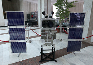
A new Belarusian-Russian satellite for the remote sensing of the Earth will be created within 2-3 years. The statement was made by Chairman of the Presidium of the National Academy of Sciences of Belarus (NASB) Vladimir Gusakov as he met with Igor Komarov, head of the Russian space agency Roscosmos, on 23 June, BelTA has learned.
Vladimir Gusakov said: “Today we are going to discuss the creation of a new satellite for the remote sensing of the Earth. It should be created in 2-3 years at most because the old satellite's service life will end at that time.”
Vladimir Gusakov said that the satellite will be created through joint efforts of the two countries. “The new satellite will boast higher image resolution — less than one meter — while the present satellite's resolution stands at two meters. It means that the satellite's imagery will be more precise. And we believe that it will be used not only for domestic purposes,” remarked the official. According to the NASB head, the images will be used commercially in Belarus and abroad. A joint venture to commercialize results of the satellite's work has already been established by the NASB and Roscosmos, said Vladimir Gusakov.
In Belarus images taken by the new satellite will be used by a number of ministries and agencies such as the Emergencies Ministry, the Agriculture and Food Ministry, the Natural Resources and Environmental Protection Ministry, and the Forestry Ministry.
“I think today we will be able to sign a joint protocol on results of the negotiations and outline further steps in creating the satellite. Research work is now in progress. Everything goes according to the plan for long-term cooperation between the National Academy of Sciences of Belarus and Roscosmos,” stated Vladimir Gusakov.
SCIENCE. TECHNOLOGY. INNOVATIONS
13.08.2024
28.06.2024
28.06.2024
25.06.2024
05.06.2024
15.05.2024
15.05.2024
26.04.2024
26.04.2024
26.04.2024